Zupa-Keret -coastline
White Sea Western coast, Karelia, Russia
12th August 1998
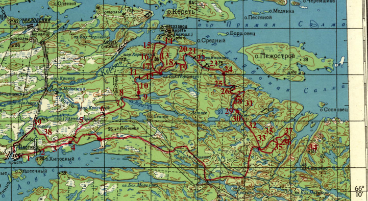
Key to the map Zupa-Keret -coastline forest and lake area. Beloje More,
White Sea Western coast, Karelia, Russia. 1 square is 4x4 kms.
- 1. Road
- 2. Bridge + swimming
- 3. Easy wetland and forest
- 4. Burned < 10 yrs gravel ridge, eskar
- 5. Wetlands, forest islets, partly cut
- 6. Rock on the side of a wetland, all cut to the South
- 7. North-South quartal line, visible in the forest, selective cuttings
> 20 yrs Electric line, partly on the ground, rock, some difficult "Mangrove"
- 8. Simming, avoid this end of the lake, North side of the lake: rocks,
used private cabin, leave forest
- 9. old > 50 yrs, wooden made dam, rock hill
- 10. Rock, dry forest
- 11. Trunk bridge, used private cabin.
- 12. Hill, dry forest, views to the North
- 13. Trail to the sea
- 14. No trail along the coast
- 15. Nice rocky hill, some views to the Keret-village, lichen on the
ground
- 16. High rocky hill, 85 meters, hice views > 180 degrees, sign tower
5 m.
- 17. Old forest on the hillsides
- 18. just like 17.
- 19. Old forest, cloudberries
- 20. Little islet, not in the maps, raft at that time
- 21. Very nice hill, pine and aspen
- 22. Small wetlands, lakes, nice rock hill, pines and lichen
- 23. pine and rock-bottom continues as in 22.
- 24. All burned 15-20 yrs ago, dry wood, bush, easy to hike > 2-3
km/hr, rocks and wetlands between them, cloudberries
- 25. Narrow lake deep between hills, nice place
- 26. Hill
- 27. Bottom of the bay, old living place (?), busy with tourists, fireplaces
etc.
- 28. Rapids, easy to cross, old wood floating constructions
- 29. Shores of the lake partly cut, bush, seedling
- 30. Hill and seedling
- 31. Small wetlands and rock
- 32. Nice clearwater lake, probably the surface is rised up by 0,5 meters
by dam. This can be seen from tree stumbs below the surface. Lichen on
the rock.
- 33. Cloudberries, wetland and rock
- 34. Viewing point, steep.
- 35. Wetland and rock -mosaic in this area.
- 36. Small valley. Probably 0,5 cubic meter stone that has fallen year
1997.
- 37. Pines far apart on the rock, views to the sea.
- 38. Track leads to the eastern end of Louhiozero, Louhijaervi.
- 39. Place to ford or swim, no bridge.
Plotina is a village of about <500 people. There is one shop, one
bus-stop. Few times a week buses run to Louhi or Zupa or maybe not, check
at the site. There's also closed mica-mine, which is interesting. This mineral
may not be "mica" but anyway it breaks easily and forms transparent
fire-resistant leaves.
[BACK]